The Turiec Region

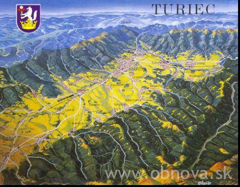
Turiec spreads in the north- western part of Slovakia. It borders on the Orava region in the north, Liptov in the east, Pohronie in the south, Ponitrie in the south- west and central Považie in the north- west. Its distance from Bratislava is 230 km, from Nízke Tatry (the Low Tatras mountain range) 80 km and 120 km from Vysoké Tatry (the High Tatras mountain range). The territory of Turiec lies in Turčianska kotlina (theTuriec basin) surrounded by the Malá and Veľká Fatra mountain ranges in the west and east, Kremnické vrchy (the Kremnica hills) in the south and Žiar Mts. in the south- west. The border, which separates the region from other territories, runs along the peaks of the ranges. The axis of the basin is the river Turiec.
The Turiec basin belongs to the one of the high- situated basins in Slovakia. The altitude above sea level moves between 500 to 700 metres in the south to 400 metres in the north.

There are about 40 mineral springs in the Turiec basin, that emanate in the surface along its deep fault lines. The most known are alkaline thermal springs in spa of Turčianske Teplice and carbonic acid mineral waters used in bottling plants in Záturčie ( Martin) and Budiš.
The Turiec region was named after the Turiec Castle, nowadays known as the ruins of the Zniev Castle. The oldest notices proved that the first inhabitants of the territory settled here in the Upper Stone Age (archeological site in surroundings of Blatnica). The territory was divided from the Zvolen County and from the first half of the 14-th century AD it existed as the Turiec administrative just. In the Middle Ages the region was a part of the trade road leading from the Podunajsko over the Ponitrie, Liptov thruogh the Orava to the Baltic. Near the road were built castles with watchtowers such as: Sklabiňa, Blatnica and Zniev. Around them later arised administrative parts. The German colonisation lead to the development of the southern part of Turiec. The region was associated with important trade roads, near them originated villages and towns such as: Martin, Sučany, Turany, Mošovce, Slovenské Pravno, and Kláštor pod Znievom (Monastery below the Zniev Castle). In years 1786- 1790 the territory had been connected to the Zvolen administrative just and as an independent territory disappeared in 1922.
TOURIST INFORMATION CENTRE
You can find us :
Touristicko-nformačná kancelária (Tourist information centre)
Divadelné námestie 1
036 01 MARTIN
SLOVAKIA
We offer :
– free services:
· information about accommodation in the town and in the Turiec region
· reservation of accommodation
· information about catering and board services
· informatiion about cultural events in the town and in the Turiec region
· information about bus and train connection
· hiring of city guides
-the sale:
·of tourist wooden badges
·of post cards and presents
·of travel insurance Union
·of tourist and cycletourist maps of the region
·of maps of the town and its surroundings
·of tickets for cultural and sport events
Contact :
tel:00421/43/423 8776, 00421/43/16186
e-mail: tik@martin.sk, www.martin.sk
Opening hours :
Monday – Friday 9,00 am – 5,00 pm


